
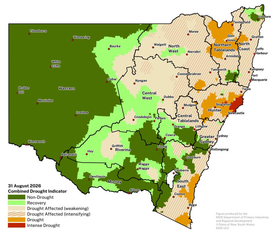
Variable winter rainfall and warmer than average temperatures drive large regional variations in seasonal conditions at the start of spring across NSW.
- Winter rainfall across southern, central and western NSW improved seasonal conditions and production outlooks in these areas. However, drought conditions persist across large parts of northern and northeastern NSW, where winter rainfall has been insufficient to alleviate long-term deficits. Winter rainfall deficits have also affected the southeast, with drought conditions emerging along the coast and eastern Monaro.
- Above average winter temperatures accelerated winter crop development and supported stronger than usual pasture growth, in growing regions with adequate soil moisture. Early season crop development may also increase the likelihood of an early finish for some winter crops if warm conditions continue through spring.
- Water availability remains mixed. Southern Basin storages have improved following winter rainfall; however, below average snow accumulation is expected to reduce spring inflows. There are signs of local hydrological stress with many farm dams across NSW having water coverage below 20% of their total area.
- The seasonal forecasts suggest a higher likelihood of drier conditions and warmer than usual temperatures for much of NSW through spring.
- Continued rainfall will be important to maintain and improve conditions and production opportunities. The warm temperatures forecast for spring will increase evaporation rates and water demand for crops, pastures, livestock water, as well as increasing losses from farm dams. Producers are actively planning for an early crop harvest or finish to the spring pasture production window, and potential stress on farm water resources if this scenario eventuates.
- The NSW DPIRD Drought Forecast to 30 November 2026 is that the current regional pattern of drought conditions is likely to persist across NSW, with some shifts in the drought intensity within Drought Affected regions.
Regional overview
- On-ground conditions and production outlooks remain positive across parts of the Central Tablelands, Central West, Riverina and Murray, where winter rainfall has supported drought recovery and improved seasonal conditions.
- The far west of the state continues to experience favourable seasonal conditions and a sound production outlook for spring.
- Long-term rainfall deficits continue to impact farm production and influence conditions in drought-affected areas of northern NSW, with a further expansion of the NSW-CDI Drought category. Recovery remains dependant on sufficient rainfall to recharge soil and surface water over spring.
- Challenging conditions continue in the Hunter, with areas around Dungog transitioning to the Intense Drought category of the NSW-CDI over the past month.
- Parts of the southeast experienced below average winter rainfall, with drought conditions expanding along parts of the south coast in recent weeks. Early spring rainfall is now critical for dryland production across the region.
- There is considerable farm to farm variability and complex transitions in on-ground conditions between regions. Along with seasonal forecasts, accurate on-ground assessments of soil water and the farms water and pasture resources are critical to guide management over the coming months.
More detail is available for each LLS region in the regional breakdown section of this Update.
Climate and drought Outlook
The most likely outcome is for drought conditions to persist across much of NSW.
- The Bureau of Meteorology’s climate outlook is for a low to neutral chances (20-55% chance) of rainfall being above the median for the three-month period to 30 November 2026.
- DPIRD’s Drought Forecast is that the most likely outcome is for drought conditions to persist across the southeast, central, eastern and northern NSW at the end of November.
- The percentage of NSW most likely to be in any drought category of the NSW-CDI at the end of the forecast period is 35% (with an uncertainty range of 22 – 45%).
- At a regional level drought conditions will likely intensify across parts of northern tablelands, Hunter and northern NSW.
More information can be found in the DPIRD Drought Forecast section.
Status of Climate Drivers
- El Niño has been underway since mid-June and continues to strengthen, with further intensification likely in the coming months. The ENSO Relative Niño 3.4 value is +2.45oC (as of 30 August 2026). The Southern Oscillation Index is currently -13.2 (as of 4 September 2026). In historical terms the index values are very high and the event is described as a strong El Niño.
- The observed Indian Ocean Dipole has returned into the neutral range over the past 3 weeks. Models continue to suggest a positive IOD could develop during the spring, although the forecast magnitude of the event remains uncertain.
- A positive phase of ENSO (i.e., El Niño) coupled with a positive IOD event would increase the likelihood of hotter, drier conditions across eastern Australia. However, the strength of either climate driver doesn’t always match the strength of its impact on rainfall and temperature in Australia.
- It is important to continue to monitor ocean and atmospheric conditions, along with rainfall and temperature outlooks over the coming months.
Northern Tablelands Local Land Services
Seasonal conditions remain challenging across much of the Northern Tablelands LLS region.
- Rainfall during August provided short-term relief across the region, but it was insufficient to drive broad-scale or sustained recovery from longer-term rainfall and soil-moisture deficits.
- Cold conditions and frost events during late winter also constrained pasture growth and recovery in many areas.
- Drought conditions continued to intensify during August, with much of the region remaining within one of the NSW-CDI drought categories.
- Livestock producers continue to implement drought-management strategies, including supplementary feeding, feed budgeting, monitoring livestock condition and welfare, reviewing stocking pressure, and assessing farm water supplies.
Click on the scroll bar below the map to compare with previous months.
The DPIRD Drought Forecast suggests that most of the region is likely to be in the NSW-CDI Drought Affected or Drought category at the end of November 2026 (issued 31 August 2026).
- There will likely be an expansion of areas in the NSW-CDI Drought category around Glen Innes.
- Some areas around Inverell are also likely to enter the Intense Drought category, while in the southeast, areas will likely remain in the Non-Drought category.
- The forecast is being driven by long-term rainfall deficits, along with the increased chance of below median rainfall for the coming three months.
- There is low to high model agreement and low to high past accuracy for this forecast period.
